VIETNAM DMZ ZONE
Explore Demilitzrized Zone
Welcome to Vietnamese Demilitarized Zone , The Vietnam War (as the West knows it) shaped the culture of a whole generation throughout much of the world. The incredible output of films, TV shows and music relating to the war is testimony to that. While it may seem a little ghoulish, it’s understandable that many tourists want to visit the names engraved in their consciousness – and not just the steady stream of Vets revisiting the places that changed their lives.
From 1954 to 1975 the Ben Hai River served as the demarcation line between the Republic of Vietnam (RVN; South Vietnam) and the Democratic Republic of Vietnam (DRV; North Vietnam). On either side of the river was an area 5km wide that was known as the Vietnamese Demilitarized Zone (DMZ). Ironically, as the conflict escalated, it became one of the most militarised zones in the world.
Vietnamese Demilitarized Zone along with the visiting the Hue tourist attractions in a day trip which takes you to the war zone dating back to the American war.The Demilitarized Zone briefly shown up as DMZ is the old border area that divided North and South Vietnam until the end of the Vietnam War in 1975. Some of the fiercest battles of the war occurred at places like Khe Sanh and Quang Tri. At least tens of thousands, perhaps hundreds of thousands of North Vietnamese, South Vietnamese and US troops as well as civilians died in battles in this area. We organize daily Excursion to Vietnam DMZ zone from Hue. The day trips includes visiting La Vang Church, Vinh Moc tunnels, Khe Sanh, Dong Ha town, Quang Tri Citadel and the Rock-pile. It is far better to book a private car and tourist guide since this will allow more flexibility, for more information.
Places to visit on Vietnam Demilitarised Zone (Dmz)
Introducing Khe Sanh Combat Base
The site of the most famous siege – and one of the most controversial battles – of the American War, Khe Sanh Combat Base (admission 30,000d; 7am-4.30pm) sits silently on a barren plateau, surrounded by vegetation-covered hills that are often obscured by mist and fog. It is hard to imagine as you stand in this peaceful, verdant land that in early 1968 the bloodiest battle of the war took place here. About 500 Americans (the official figure of 205 was arrived at by statistical sleight of hand), 10,000 North Vietnamese troops and uncounted civilian bystanders died amid the din of machine guns and the fiery explosions of 1000kg bombs, white-phosphorus shells, napalm, mortars and artillery rounds of all sorts.
The site includes the recent addition of a small memorial museum. A couple of bunkers have been recreated and some photos and other memorabilia are on show. Behind the main site, the outline of the airfield remains distinct – to this day nothing will grow on it. Some of the comments in the visitors’ book, especially those written by visiting war veterans, can make for emotional reading.
Military Sites On Highway 9
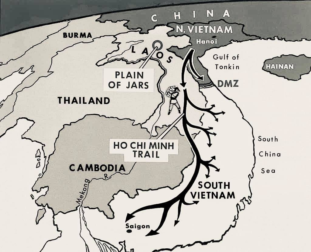
Beside Vietnamese DMZ zone, the legendary Ho Chi Minh Trail – the main artery of supplies for the North’s war effort – was not one path but many, leading through the jungles of the country’s mountainous western spine. In an effort to cut the line near the border, the Americans established a series of bases along Hwy 9, including (from west to east) Lang Vay, Khe Sanh, Ca Lu (now called Dakrong Town), The Rockpile, Camp Carroll, Cam Lo, Dong Ha, Gio Linh and Cua Viet. Ultimately their efforts were unsuccessful.
Truong Son National Cemetery
An evocative memorial to the legions of North Vietnamese soldiers who died along the Ho Chi Minh Trail, this cemetery is a sobering sight. More than 10,000 graves dot these hillsides, each marked by a simple white tombstone headed by the inscription liet si (martyr). Many graves lie empty, simply bearing names, representing a fraction of Vietnam’s 300,000 soldiers missing in action. Truong Son was used as a base by the May 1959 Army Corps from 1972 to 1975. The corps had the mission of constructing and maintaining the Ho Chi Minh Trail. The cemetery is not on most tour itineraries, and its isolated location and simple design give it a powerful dimension. It’s 27km northwest of Dong Ha; the turn-off from Hwy 1 is close to Doc Mieu.
Hamburger Hill, a sight near DMZ zone
Hamburger Hill is 8km northwest of Aluoi, about 6km off Hwy 14. It’s less than 2km from the Laos border. Security is tight around here and you’re sure to get your permits inspected by border guards.
Map of the DMZ zone in Vietnam
Fast forward several decades and there’s not much left to see in and around the DMZ zone. Most sites have been cleared, the land reforested or planted with rubber and coffee. Only Ben Hai, Vinh Moc and Khe Sanh have small museums. Unless you’re an American veteran or military buff, you might find it a little hard to appreciate the place – which is all the more reason to hire a knowledgeable guide. here is the map of the whole are covering HCM trail and the Demilitarized zone of Vietnam
History of Demilitzrised Zone (DMZ)
Regarding the history of the Vietnamese Demilitarized Zone, the idea of partitioning Vietnam had its origins in a series of agreements concluded between the USA, UK and the USSR at the Potsdam Conference, held in Berlin in July 1945. For logistical and political reasons, the Allies decided that the Japanese occupation forces to the south of the 16th Parallel would surrender to the British while those to the north would surrender to the Kuomintang (Nationalist) Chinese army led by Chiang Kaishek. This was despite the Viet Minh being in control of the country by September that year – Vietnam’s first real taste of independence since 1887.
In April 1954 at Geneva, Ho Chi Minh’s government and the French agreed to an armistice; among the provisions was the creation of a demilitarised zone at the Ben Hai River. The agreement stated explicitly that the division of Vietnam into two zones was merely temporary and that the demarcation line did not constitute a political boundary. But when nationwide general elections planned for July 1956 were cancelled by the South who predicted a Viet Minh win, Vietnam found itself divided into two states with the Ben Hai River, which is almost exactly at the 17th Parallel, as their de facto border.
During the American War, the area just south of the Vietnamese Demilitarized Zone was the scene of some of the bloodiest battles of the conflict. Quang Tri, The Rockpile, Khe Sanh, Lang Vay and Hamburger Hill became household names in the USA as, year after year, TV pictures and casualty figures provided Americans with their evening dose of war.
Since 1975, 5000 people have been injured or killed in and around the Vietnamese Demilitarized Zone by mines and ordnance left over from the war. Despite the risk, impoverished peasants still dig for chunks of leftover metal to sell as scrap, for which they are paid a pittance.
Demilitarized Zone Tour from Hue
Demilitzrized zone tour is an interesting and worth-a visit day tour from Hue city. Tour usually takes from 8 am to 4 pm and you will be learning about the war between Vietnam and the America while enjoy a scenic ride through the beautiful countryside of the Quang Tri city. Discover historical Ho Chi Minh Trail and visit US Air base and learn about army surveillance used back in the day. The local guide will explain you about the history of the DMZ zone while touring you around the Demilitarized zone.
DMZ Zone tour of Vietnam from Hue, in English, includes lunch & transfer
What will you experience on a ZMD zone tour?
The ZMD zone tour usually start at 8 am and you will be picked up from your hotel in Hue city and you will be driving to Quang Tra town where you will start your day visiting following places:
Dong Ha Town used to be a strategically important location of U.S. Marine Combat Base, as an outpost to provide surveillance of troop movements across the Demilitarized Zone (DMZ).
Doc Mieu base – one part of an elaborate electronic system (McNamara’s wall) intended to prevent infiltration across the Vietnamese Demilitarized Zone.
Hien Luong bridge is known as the “Peace Bridge”, a beam bridge built from steel by the French in 1950.
Ben Hai river: an important landmark in the partition of the country into a northern and a southern zone along the 17th parallel by the Geneva Accords of 1954.
Cua Tung beach: the river flows from west to east just south of the 17th parallel and close to the northern border of Quang Tri Province.
Vinh Moc tunnels: The complex of tunnel, located deep in the Vietnamese Demilitarized Zone, including wells, kitchens, rooms for each family and spaces for healthcare.
Dakrong bridge: crossing the Dakrong river.
Ho Chi Minh trail: was a logistical system that ran from the North Vietnam to the South Vietnam crossing through the neighboring kingdoms of Laos and Cambodia.
Rock pile: a base for American long – range artillery nearby.
Khe Sanh combat base: is a valley surrounded entirely by rolling mountains and forest, was one of the most controversial battles – of the American War.
Copyright 2013-2017 Vietnamese Private Tours Ltd With Vietnam Luxury Travel

